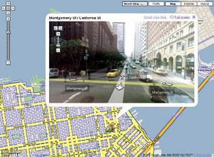
Google Maps new features
Friday, June 01, 2007
 Google has added a feature called “Street View”, but only in certain locations on Google Maps. “Street View” displays an interactive panorama photo of some locations.
Using Street View:
In certain locations, you can view and navigate within street-level imagery. Here's how:
-Blue outlines show roads where street view is available.
-The green arrow points in the direction you're looking. You can drag the icon to navigate to a different location. You can also just click on a blue outlined road to go there.
-Drag the street view to look around 360°. Use the arrow buttons to navigate down the street. You can also use the arrow keys on the keyboard
Source & Image:
Google Maps
Labels: technology

